


Early maps
Die Liste enthält 1 Eintrag. Suchergebnisse löschen und Gesamtbestand anzeigen.
| Abbildung |
Beschreibung Gesamte Buchaufnahme |
Preis EUR |
|
|---|---|---|---|
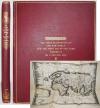 |
Stevens, Henry Newton. The first delineation of the new world and the first use of the name America on a printed map. An analytical comparison of three maps for each of which priority of representation has been claimed … London, Henry Stevens, Son and Stiles 1928. Gr.-4° (32,5 x 26,5 cm.). XVI, 127, (4) pp. and 2 folded maps (″The Stevens-John Carter Map“ and „The 1513 Ptolemy Map“). Publisher’s cloth with gold-embossed titles on the spine and cover.
An important cartographic study by the influential British antiquarian bookseller and bibliophile H. N. Stevens (1855-1930). His father, Henry Stevens of Vermont (1819–1886), was the legendary American bibliographer who effectively pioneered the market for ‘Americana’ in London and supplied major collectors as well as the British Museum. – Stevens compares three historical maps, each of which has been claimed to be the first to depict the New World. Two of these maps bear the name ‘America’, whilst one does not. He argues, on the basis of coastlines, inscriptions and technical details, that the copy discovered in 1893 and held at the John Carter Brown Library is the earliest. This study is closely linked to Martin Waldseemüller’s monumental world map from 1507, which is regarded as the milestone on which the name ‘America’ first appeared. – A fine copy of the rare first edition. Schlagwörter: America, Americana, Amerika, Early maps, Kartographie |
120,-- |  |
|
Eintrag 1–1 von 1
Zurück · Vor
|
|||
| Seite: 1 |